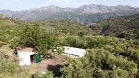
Descripcion del inmueble: Finca de olivar con ruina, nave y aperos en Atajate, Valle del Genal alto, Serranía de Ronda, Málaga, Andalucía, España.
Finca 9 hectáreas de terreno con semiplano con zonas algo más pendientes y zonas llanas. Arbolada de olivos, castaños y almendros mayoritariamente pero también tiene parte de la finca, 3 Ht, de regadío con papeles y arbolada con Nogales, cerezos, y algunos frutales variados, ciruelas, higueras y parras.
vallada para saber las lindes.
Las construcción de que dispone son unos restos de una antigua construcción en ruinas, un almacén de unos 45 metros cuadrados y otro almacén de unos 12 m2.
Dispone de agua de un pozo de perforación de unos 40 metros de profundidad legalizado y tiene posibilidad de poner luz de la red.
Parte del terreno es semi plano parte algo más pendiente y tiene grandes zonas llanas.
La finca tiene subvención parte por olivos y parte por no arar.
Tiene orientación Norte y vistas panorámicas.
Linda con un arroyo por oeste, un camino de entrada por el norte, la cresta de la montaña por el sur y con un vecino por el este.
Acceso por camino de tierra bastante llanito y no muy ancho, a algo menos de 1 kilómetro de Atajate. Dos entradas, una por la parte baja otra por la parte alta
|
*: Olive grove with ruin, shed and tools in Atajate, upper Genal Valley, Serrania de Ronda, Malaga, Andalusia, Spain.
Finca 9 hectares of land with semi-flat land with slightly steeper slopes and flat areas. The land is mainly planted with olive, chestnut and almond trees, but also has part of the land, 3 Ht, irrigated and planted with walnut trees, cherry trees, and some fruit trees, plums, figs and vines.
Fenced to know the boundaries.
The construction is the remains of an old building in ruins, a warehouse of about 45 square metres and another warehouse of about 12 m2.
It has water from a borehole of about 40 metres deep, legalized and has the possibility of putting mains electricity.
Part of the land is semi-flat, part is more sloping and has large flat areas.
The land is partly subsidised by olive trees and partly not ploughed.
It has north orientation and panoramic views.
It is bordered by a stream to the west, a driveway to the north, the mountain ridge to the south and a neighbour to the east.
Access by a fairly flat and not very wide dirt track, just under 1 kilometre from Atajate. Two entrances, one from the lower part and one from the upper part.
|
|
|


